Top 10 Places to See the Fall Colours in Algoma Country

Leaves are beginning to change colours in Northern Ontario.

Leaves are beginning to change colours in Northern Ontario.

While September might be a student’s nightmare due to the dreaded back to school blues, for me, it stands as one of my absolute favourite months. September brings warm days and cool nights, perfect for camping and sleeping out under the stars. The waters in the Great Lakes are still warm enough to enjoy a dip, and summer tourists have returned back to their homes, leaving trails and popular destination spots quieter. Most impressively, the Maple trees transition from their evergreen colours to brilliant shades of orange, red, yellow, and even purple by mid-September. Northern Ontario becomes a sea of bright shades and hues, a colour chaser’s paradise.

Across Ontario, there are plenty of places to see the changing of the leaves. However, Northern Ontario promises spectacular views against the backdrop of great bodies of water, including Lake Superior. Below is a list of some of the top 10 places (in no particular order) that colour chasers can view the changing of the Maple trees in the Algoma region while also enjoying breathtaking views of Northern Ontario water. This list is not exhaustive, but instead, a list of my personal favourite hotspots.

Before heading out on the trails, be sure to check out Ontario Park’s weekly Fall Colour Report, which highlights optimal viewing for colour chasers across the Province of Ontario.

  1. The Pancake Bay Lookout Trail.

Located only 45 minutes north of Sault Ste. Marie, the Pancake Bay Lookout Trail is an easy six-kilometre trail which boasts a scenic lookout over mighty Lake Superior, the white sands of Pancake Bay, and the graveyard of the Great Lakes, where the historic Edmund Fitzgerald met her demise on 10 November 1975.  After climbing metal and wooden stairs to reach the worn platforms which dot the top of a cliffed mountain, the lookout is always worth the hike – no matter the season and the weather. Once at the lookout, viewers can see for miles. To the left stretches the Boreal Forest and continues onto the right.  In front, down below, lies the TransCanada Highway, and a body of freshwater encompasses the horizon. In the fall months, the trees adorn their fall colours, appearing as a sea of bright hues jarring out of the Canadian Shield, stopping abruptly for the pure white sand which meets the cool, blue waters. The Lookout Trail truly is the perfect fall hike.

  1. Robertson Cliffs Trail

Located only 15 minutes outside of Sault Ste. Marie exists the Robertson Cliffs and King Mountain. Jutting out of the lowlands in Goulais (pronounced “Goo-lee”) stands these picturesque mountains, which offer panoramic views of the boreal forest, the Trans Canadian Highway, and mighty Lake Superior. Many label the Robertson Cliffs trail as difficult. However, the trail is rather simple, except for the first kilometre, in which hikers climb approximately 180 metres (or 600 feet) in elevation to reach the top of the mountain, where they are greeted with five impressive lookouts, perfect for viewing the fall colours. The Robertson Cliffs Trail also offers up a small waterfall viewing opportunity. This is a great hike for those looking to escape the city for a few hours without wanting to venture far.

  1. Nokomis Trail

Located across from Old Woman Bay at the northern boundary of Lake Superior Provincial Park (approximately 20 minutes south of Wawa, Ontario), the Nokomis Trail is a moderately difficult five-kilometre trail system that provides five stunning lookouts, sky high above Old Woman Bay, one of the most popular stops within Lake Superior Provincial Park. Viewers can enjoy breathtaking views of the Old Woman River, Old Woman Bay, and the rolling glacial mountains, which appear as a sea of bright colour in the fall months. On a windy day, hikers can experience first hand the legacy of mighty Superior, as waves crash 10 feet high at Old Woman Bay. (Stay tuned for a detailed trail report on the Nokomis Trail!)

  1. Highway 129 to Chapleau

As much as I love hiking, I also love taking fall drives. Consider taking a drive along Highway 129 from Thessalon, Ontario to Chapleau, Ontario. Over two hours in length one way, the drive offers views of uninterrupted Northern Ontario. Drivers get close – sometimes too close – to the edge of the Mississaugi River, as the highway hugs the river, as well as other lakes and tributaries. As you drive along, enjoy the winding and rolling of the highway, as well as the never-ending rolling of the mountains. Onlookers can also enjoy glimpses of the remains of a devastating forest fire, Pig Pen Chutes, and the Chapleau Game Preserve, the largest game preserve in Ontario. With few towns and communities on this solitary highway, your chance of seeing wildlife as well as the fall colours is extremely high. Be sure to get gas before leaving Thessalon, Ontario, however; there are very few opportunities to gas up along the way!

St. Joseph Island Bridge

Fall colours at Hiawatha Highlands.

  1. Hiawatha Highlands

Located within the City of Sault Ste. Marie, off of Fifth Line, Hiawatha Highlands is one of my favourite year-round stomping grounds. With amazing trails for biking, hiking, and running in the spring, summer, and fall, and strenuous cross-country ski tracks and snowshoe paths in the winter, Hiawatha is every Saulite’s favourite recreational place within the city limits. Trails range from one-kilometre in length to over 15-kilometres, and can be anything from easy to moderately difficult. The Crystal Falls, a gorge, and various lookout vantage points also provide trail users with a great views of the city and vast wilderness. To me, Hiawatha is perhaps one of the best places to view the fall colours, since the majority of the trails are lined with thousands of Maple trees. Trail users can spend anywhere from an hour to a full day exploring the Hiawatha Highlands.

  1. St. Joseph Island

    P10305732

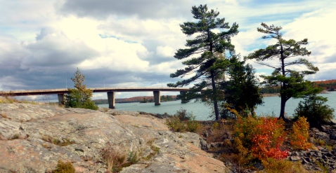
    Fall colours at the St. Joseph Island bridge.

No matter the season, you can’t go wrong visiting St. Joseph Island. The majority of St. Joseph’s Island’s tree population consists of Maple trees, so a visit in the fall is sure to impress. Take a drive around the entire island on Highway 548, take in the shipping channel at Sailors’ Encampment, visit a quaint store in Richards Landing, or hike the Mountainview Centennial Grounds’ trails in Jocelyn Township. You can stay for an hour, a day, or overnight. And there’s no better home-cooked meal than on St. Joseph Island.

The Chippewa Falls in the fall season, as season from Highway 17, travelling to Wawa, Ontario.

The Chippewa Falls in the fall season, as season from Highway 17, travelling to Wawa, Ontario.

  1. Highway 17 North to Wawa

Did you know that the Lake Superior Circle Tour is considered one of the top 10 drives in Canada? The trip around Lake Superior is absolutely spectacular. However, not everyone has the time to make a 16-hour or more drive around Lake Superior. If you do, however, I highly recommend it. For those of us who can’t spare that much time, consider the drive from Sault Ste. Marie, Ontario to Wawa, Ontario.  Approximately 220 kilometres (137 miles), this two-hour drive will not disappoint and will deliver spectacular views of the Boreal Forest, the Canadian Shield, and the rugged coastline of Lake Superior. Two waterfalls – the Chippewa Falls and Pinguisibi (Sand River) Falls will also highlight the trip. And for food lovers, there are plenty of options for a good home-cooked meal along the trip. And did I mention there are some good arts and crafts stores as well? The drive to Wawa is also a great alternative to the Agawa Canyon Tour Train, for those on a tighter budget. Onlookers will enjoy similar views that they would see on the Tour Train, except for the view of the Agawa Canyon itself; however, they will get to enjoy Lake Superior. If you do take this drive, be sure to have a full tank of gas – there are no gas opportunities between Batchewana Bay and Wawa, Ontario.

  1. Agawa Canyon Tour Train

The Agawa Canyon Tour Train is the most popular tourist stop within Sault Ste. Marie. Every year, thousands from around the globe visit the Sault to climb aboard the Algoma Central Railway (ACR) and head to the Agawa Canyon. Visitors can enjoy a full day onboard the train in refurbished cabins, taking in the sites along the rails, including rivers and streams, windfarms, bridges and trusses, and vast mountainous landscapes.  Once at the canyon, train travellers have just under two hours to explore the Agawa Canyon, enjoy lunch, hike over 300 steps to the lookout, or visit two impressive waterfalls. The Agawa Canyon Tour Train is truly impressive and promises views nature enthusiasts can see no other way. The Agawa Canyon is visible only via the Agawa Canyon Tour Train. For extreme backcountry hikers, an almost non-existent trail can also be hiked to the Canyon. Warning: not many people have successfully hiked this extremely difficult trek. For more information, please visit the Agawa Canyon Tour Train website. 

  1. Awausee Trail

Unlike the Nokomis Trail in Lake Superior Provincial Park, the Awausee Trail is difficult and demands a higher level of expertise and physical ability. 10 kilometres long, the trail is located only minutes from the Agawa River and Agawa Bay Visitor Centre at the south entrance of Lake Superior Provincial Park. For the first two kilometres of the trail, hikers climb to an elevation greater than 300 metres above Lake Superior. The hike up the mountain is agonizing, but the views are unlike anything you’ve ever seen – I promise. Few trails in the Algoma region reach the same elevation as the Awausee Trail. Therefore, before heading out for this hike, check the weather carefully: schedule your hike on a clear, sunny day. I hiked this trail in a thunderstorm and couldn’t see through the clouds at three of the five lookout posts.

  1. Pinguisibi River

Next to the wonder that is Old Woman Bay, Pinguisibi River within Lake Superior Provincial Park sparks within me an incredible sense of awe and inspiration. It is undoubtedly, my most cherished spot within Ontario. More commonly known as the Sand River due to its English translation from Anishinaabemowin (Ojibwa language), the Pinguisibi River provides access to the most reachable waterfall and its three chutes within Lake Superior Provincial Park. So accessible in fact, that it can be seen from the Trans-Canada Highway, making it one of the most popular stops within the park, but also the most popular hiking trail. Although it is considered a moderately difficult trail by the park’s standards, this six-kilometre linear hike is an easy trek, perfect for families, adventure enthusiasts, and those both young and old. Well maintained by the interior provincial park staff, equipped with a well-trodden trail, bridges, and wooden steps, the Pinguisibi River is a must-see stop for those travelling along Highway 17. Plus, if you’re an angler, this river never disappoints.

What’s your favourite place to see the fall colours?

Want to know more about any of these locations or to see pictures from my past travels to these places? Contact me directly at thenorthjunction@hotmail.com or comment on this post.

Tales from the Pancake Bay Lookout Trail: The Perfect Fall Hike

Growing up, I always loved summer, and cherished my time at the beach and in the warm waters of Old Mill Bay.  However, in recent years, I have a new fondness for fall.  Warm days, cool nights, coloured trees and crispy fallen leaves, hot chocolate, wearing scarves, mittens, and toques, and hiking my preferred trails, makes the fall months of September and October two of my favourites, and has me longing for them in the humid months of July and August.

Fall happens to be one of my most active seasons, where I venture north and east of Sault Ste. Marie to explore the Algoma region.  Free from the rising temperatures of the summer days and the mosquito season, I can be found in the backwoods of the Superior north shore, or with my feet buried in the sand and a book in my hands at one of my favourite secret beaches.  While fall continues to be a popular tourist season in the Algoma area due to peoples’ interest in chasing the changing colours on our proud Maple trees, the hiking trails and beaches fall secluded, and give way to time to reflect and be alone with nature.

Every year, I make it a habit to venture along one of my favourite hiking trails on Highway 17.  This year, I decided to take the trek earlier, wanting to enjoy the luscious greenery that encompasses the forest floor, and enjoy the warm summer breeze from great heights. Just north of Pancake Bay Provincial Park lays an easy six-kilometre trail which boasts a scenic lookout over mighty Lake Superior, the white sands of Pancake Bay, and the graveyard of the Great Lakes, where the historic Edmund Fitzgerald met her demise on 10 November 1975.  I always try to venture up the highway during the final week of September, usually when the colours on the deciduous trees have reached their optimal peak, showing off vibrant colours of yellow, red, and orange, just before they begin to turn brown and make their descent to the forest floor.  With the close companion of a friend, and my favourite spaniel at my feet, a 45-minute drive north of Sault Ste. Marie places us hikers at the Ontario Park entrance, and another two-minute jaunt up the highway takes us to the trail head of the Lookout Trail.  Located on the right-hand side of Highway 17 when heading northward, the trail is marked by a green sign which reads “Lookout Trail”.

The Lookout Trail provides for spectacular views of luscious forest. Towering Maple trees shelter the trail, providing adequate shade to the forest floor and hikers.

The Lookout Trail provides for spectacular views of luscious forest. Towering Maple trees shelter the trail, providing adequate shade to the forest floor and hikers on hot summer days.

A relatively simple trail, which takes less than two hours in its entirety, it is highlighted by the occasional freshwater spring and rock face. It has few inclines, making the trek a relaxing and leisurely stroll through a heavily-ferned forest.  A hidden gem, few people know of the route, making the option of sighting nature’s majestic creatures in their element a definite possibility.  Having seen many deer, birds, and the occasional black bear roam the trail and forage for food, including wild berries and insects, the hike promises remarkable sites.  Perhaps even more remarkable than the wildlife that makes the trail their home, are the breathtaking views which mark the path, three kilometres in.

After climbing metal and wooden stairs to reach the worn platforms which dot the top of a cliffed mountain, the lookout is always worth the hike – no matter the season and the weather.  To the left stretches the Boreal forest for as far as I can see, and continues onto the right.  In front, down below, lies the Trans Canada Highway, and a body of freshwater encompasses the horizon. In the fall months, the trees adorn their fall colours, appearing as a sea of bright hues jarring out of the Canadian Shield, stopping abruptly for the pure white sand which meets the cool, blue waters. The Lookout Trail truly is the perfect fall hike.

After hiking three kilometres, hikers are greeted with this spectacular view, which looks over the Boreal forest and the beautiful white sand beach of Pancake Bay on Lake Superior.

After hiking three kilometres, hikers are greeted with this spectacular view, which looks over the Boreal forest and the beautiful white sand beach of Pancake Bay on Lake Superior.

The Pancake Bay Lookout Trail overlooks the graveyard of the Great Lakes, where the Edmund Fitzgerald met her demise on 10 November 1975.

It is in these moments of taking in the amazing panoramic views – which never cease to amaze me, despite having hiked the trail upwards of 10 times – I am always reminded of my studies in History, and how much has taken place in this region, which is now on display before me.  As already mentioned, in 1975, the Edmund Fitzgerald along with her unfortunate crew, were rendered helpless to a November gale-force storm, sinking her remnants to the Superior floor, and forever entrenching her and mighty Lake Superior’s legacy. Her grave site lay in the distance before me, miles and miles off shore near the Township of Whitefish, Michigan. With binoculars, I can spot the lighthouse at Whitefish.

But perhaps even more remarkable, and most often forgotten about, were the brave souls of the French Canadians, the Voyageurs, who paddled the open waters in birch bark canoes with no protection from such storms and forces, which destroyed the likes of the Edmund Fitzgerald.  In their 36-foot handmade canoes, the Voyageurs would make the trek back from remote trading posts in Northwestern Ontario, like those in Thunder Bay, back through to Sault Ste. Marie.  Having made the treacherous voyage across the north shore, through tumultuous areas like Old Woman Bay, where wide open Superior gusts in all of her glory, the Voyageurs were treated to the calmer, placid waters of sheltered Superior, including Pancake Bay and Batchewana Bay.  Plus, only being a mere 75 kilometres from Sault Ste. Marie, a locale where they could replenish much needed supplies, legends state that the Voyageurs would feast at the sandy shores on the remainder of their food, which included flour.  Using their flour, they would marvel in a feast of pancakes and then continue their trek – hence the name Pancake Bay.

For the Voyageurs, Pancake Bay was a place of celebration, having endured and survived yet another dangerous journey across open waters.  For myself, the hike at Pancake Bay is also one of celebration.  I am reminded of how lucky I am to live in an area of such grandiose and untainted beauty; how fortunate I am to not have a skyline jarred by skyscrapers; how wonderful it is to be able to breathe the fresh air made clean by the millions of trees that surround me; and how precious the feeling of the warm breeze made cool by the lake air truly is.

After marvelling in the glory of the scenery and the spectacular views, we descend back down the stairs, and return on the same trail originally taken.  Upon returning to the vehicle, like the Voyageurs, we are treated to a celebration, a quick stop at either the Agawa Indian Crafts and Canadian Carver or the Voyageurs Lodge and Cookhouse, where we enjoy a delicious treat before returning back to our busy lives in the city.

Healthy Parks, Healthy People: Free Ontario Parks Day-Use July 17th

On Friday, July 17th, get out and explore our very own Ontario Parks. Back by popular demand is the “Healthy Parks, Healthy People” event, in which Ontario Parks across the province open their doors – or gates – for free day-use. That means all fees for day-use activities are waved. So grab your friends, your pooch, family, a picnic basket, maybe even your bike, canoe, or kayak, and take advantage of this annual event where you can enjoy hiking, swimming, fishing, and more. And why not stay late and enjoy a sunset – this free event lasts until midnight! Some Ontario Parks even have special events planned to coincide with the all-day all-parks public access.

Why not stay late and enjoy a sunset? The Ontario Parks free day-use event gives you access to all Ontario Parks until midnight.

Why not stay late and enjoy a sunset? The Ontario Parks free day-use event gives you access to all Ontario Parks until midnight. (Location: Agawa Bay)

The annual Healthy Parks, Healthy People event, has become a popular tradition amongst the Ontario Parks, which promotes vigorous active living. Did you know that spending time in nature promotes physical, mental, social, and emotional well-being? The occasion is actually part of a larger worldwide phenomenon, also titled Healthy Parks, Healthy People, which works to demonstrate the positive relationship between nature and healthy lifestyles. The movement began in 2010 after the International Healthy Parks Healthy People Congress, and through events, research, case studies, and other programming, works to emphasize the ideal that human contact with the natural world is beneficial. Each year, over 10,000 million people worldwide visit the over 330 Ontario Parks in Canada, with visits spiking during the Healthy Parks, Healthy People event. Operated by the Ministry of Natural Resources, the Ontario Parks cover 78,000 square kilometres or 30,460 square miles of land, which equates to approximately 10 per cent of Ontario’s surface area. Ontario Parks provide recreation, preservation, and conservation, but also education, inspiration, and relaxation for vacationers. The provincial park system dates as far back as 1893, when Algonquin Provincial Park first opened its doors, which today stands as one of the largest parks in the province, open year round. What’s the largest park? Well, that’s no other than Polar Bear Provincial Park, accessible only by plane, which is located on the most northern part of Ontario. It’s literally in the tundra and aptly named after the polar bears which call the region home.

Enjoy a free hike to the Agawa Rock pictographs that were painted over 400 years ago by First Nations people. It's a short hike, only 400 metres.

Enjoy a free hike to the Agawa Rock pictographs that were painted over 400 years ago by First Nations people. It’s a short hike, only 400 metres.

While I have yet to visit every Ontario Park – trust me, it’s on my bucket list and it should also be on yours – I already have a personal favourite, one that I cannot go a year without visiting. For me, Lake Superior Provincial Park remains my home away from home, the place where I can go to be disconnected from the world (and sometimes civilization) and be completely surrounded by only the most stunning natural beauty. Solitude, isolation, perfection, magnitude, wonder, and breathtaking are just a few of the sentiments aroused within me upon passing the large cement sign, welcoming me into the park’s bounty. Located approximately an hour and 45 minutes north of Sault Ste. Marie, this vast park (which covers approximately 1,550 square kilometres or 600 square miles) is one of Ontario’s eldest parks.  Located on the north-eastern shoreline of Lake Superior, Lake Superior Provincial Park gained provincial park status in 1944 for two reasons – though there really are endless reasons to protect this magnificent land. First, pictographs can be seen at Agawa Rock on the outskirts of Agawa Bay, which are believed to be over 400 years old. Painted by the Ojibwa peoples in red ochre, the pictographs served as a communication tool on the mighty Lake Superior waterway. Secondly, in the Red Rock region, which is in the more northern corridor of the park, there are traces of ancient volcanic activity, as well as artefacts from various First Nations communities, which with the help of carbon dating, reach back to approximately 500 B.C. Lake Superior Provincial Park will be taking part in the annual event, and is also hosting numerous special events to coincide with free day-use. Park users can enjoy a guided hike titled “Living on the Edge” from 11:00am – 1:00pm, where hikers will walk a portion of the rugged and difficult Coastal Trail and examine the existing fauna in the region. Those interested should meet at Katherine Cove. A warning, however, the Coastal Trail is not meant for novice hikers. “Park Talks” is also happening that evening at 8:00pm at the Agawa Bay Visitor Centre, where park staff will share stories and tales of Lake Superior Provincial Park. Pancake Bay, another park located approximately 45 minutes north of Sault Ste. Marie, will also be hosting special events. Users can enjoy “Yoga on the Beach” at 1:00pm. Those interested should meet at the Picnic Shelter before proceeding to the beach. A friendly “Staff versus Campers Soccer Baseball Game” will also be had on the main field of the Park Office at 6:30pm. For a complete listing of events happening on Healthy Parks, Healthy People day, please visit www.ontarioparks.com/hphp. And if you’re finding yourself unable to find transportation to an Ontario Park near you – specifically within the Southern Ontario region – consider the Parkbus. The Parkbus is a great non-profit initiative, which began in 2010, and provides affordable transportation for nature and adventure enthusiasts to Algonquin, Killarney, and Grundy Lake Provincial Parks. The Parkbus also makes stops at Tobermory, Ontario and the Bruce Peninsula National Park. Be sure to get out and enjoy the fresh air on July 17th – your body and mind will appreciate it. You’ll find yourself feeling relaxed and rejuvenated, and perhaps, better in touch with your natural surroundings. Sources: Ontario Parks and Healthy Parks, Healthy People Central